To spend your life living in fear, never exploring your dreams, is cruel.

Saturday, June 12, 2010

Day 3/4: Beyond The Great Ocean Road


A fairly relaxed day today, looking around the sites of Mt Gambier and the region. Mt Gambier is 'the city of craters, lakes, caves and sinkholes' according to the tourist brochures, and it's the second largest city in South Australia, lying halfway between Adelaide and Melbourne. Most tourists come to see the crater lakes area, which I rode around in the morning.

The blue lake and the valley lake (bottom picture) are the only lakes remaining that contain water (though one tour guide thought that the valley lake will become dry within the next decade), and they are both impressive. The blue lake is the big drawcard; apparently the water turns a brilliant turquoise colour in the summer due to the surrounding limestone. Mt Gambier gets its water from the blue lake and you can even tour the pumping station. The centenary tower, overlooking browne's lake (dry) and valley lake is worth the short steep walk from the car park.

From the crater lakes I went South towards the coast to Dingley Dell, the former home of the famous poet and horse jockey Adam Lindsay Gordon, who shot himself aged 36. The small restored house was an interesting visit due to the enthusiasm of the owner. From there I took a ride along the coast, having lunch in Port MacDonnell, and then back to Mt Gambier, stopping at Mt Schnack. Mt Schnack is a volcano crater similar to those in Auckland. You have to walk up (30 mins return) to the top to peer into the crater, but time was getting on so I decided against it.

Back in Mt Gambier I had a look at the three city sinkholes: the Engelbrecht cave, the Umpherston sinkhole and the cave gardens. The cave gardens looked particularly idiosyncratic, being located just behind the main road. Then back to the jail for some rest, avoiding the cute inquisitive alpaca that for some unknown reason is tethered outside the building.

Riding Distance: 110 kms

Day 2/4: Beyond The Great Ocean Road


The main attraction in Port Fairy is Griffiths Island, which is linked to the mainland by a footbridge. In the morning I did the picturesque one hour walk around the island, passing the historic lighthouse. The sight of me in full bike gear walking on the beach may have been odd, but on this blustery morning there was only a wallaby to share it. He hopped along side me, looking curiously as if to say 'What the hell are you?'. I liked Griffiths Island.

I took in the amazing coastal views along the local Ocean Drive, then rode inside the disappointingly uninformative historical cemetery. With Port Fairy covered, I headed to Portland, stopping at the Codrington Windfarm viewing area along the way. The windfarm even does guided tours for pre-booked groups. I'm not sure what they would entail. 'Here's a gigantic windmill. And here's another gigantic windmill. In fact, there's about 20 of them. I hope you enjoyed the tour.'

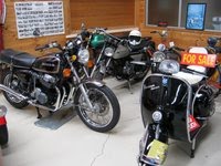
Portland could have been the state capital had history taken a different turn. As I rode aimlessly about the town centre, I happened upon a vintage car museum. It had a few old bikes inside, including a four cylinder 750cc Honda that didn't look too dissimilar to my GS500. The guy at the museum had a hobby of restoring old bikes, and after an interesting chat I went down to Cape Bridgewater and the blowholes on the shipwreck coast (35 kms return). The end of the road bisected yet another windfarm; the sea was impressively tempestuous.

After lunch I set out for Mt Gambier on the slightly less direct but far more scenic Discovery Bay Road (C192), where pine forests stretch out in all directions. I hit the state border, denoted by an impressive South Australia sign and a less than impressive Victoria one. I had nothing to place in the quarantine bin, and I couldn't set my watch back half an hour since it went kaput the day before, so I ploughed on into South Australia grateful for the increase in speed limit (to 110 km/h) and the lack of useless Victorian signage ('sleep now or die imbecile').

A fairly early arrival in Mt Gambier meant a relaxing evening walking in town. I'm staying at the old jail, which is literally an old jail. It seems to be split into two areas: one for travellers and one for a purpose I can't determine. Weird. But weird is good.

Riding Distance: 250 kms

Friday, June 11, 2010

Day 1/4: Beyond The Great Ocean Road


I've just returned from Perth and Fremantle, both very pleasant places and neither of which I had visited before. Closer to home, I've never visited Mt Gambier in South Australia either. So that was the plan for this trip, stopping at some points on the coast West of the famous Great Ocean Road.

A very late start and city traffic meant that I had to minimize delay if I were to reach my intended coastal target of Port Fairy (lighthouse in top picture) before nightfall. I headed to Geelong and took the Hamilton Highway, stopping at the very tiny town of Lismore for some nice pub grub at the Lismore Hotel. Lismore also has free tea for visitors, a fact which is well sign-posted along the highway. It wasn't the best ride: windy and wet, and colder than I expected, and the police were out in force. The dark clouds and the mist took away all the scenery. When I stopped I noticed that the rain cover on one of my panniers had almost completely fallen off, and was only being held on by the passenger footrest. I got lucky, as it didn't interfere with the back wheel. I'll now make sure that checking the drawstrings on the rain covers is part of my pre-ride checks. Lesson learned.

After the pub grub things cleared up a bit and the rain fortunately stayed away. I headed to Warrnambool, taking the Hopkins Highway at Mortlake, and then to Port Fairy on the Princes Highway another 25 or so kilometers along the coast, where I eventually found the YHA Hostel (bottom picture). My luck was in, getting a dorm room all to myself.

Riding Distance: 320 kms

Tuesday, May 25, 2010

Very Open Source


My work-laptop is an Acer TravelMate 6292. It's about three years old now, with a 150GB hard disk, 2GB RAM and an Intel Core Duo 2GHz processor. This week I installed Debian Linux on it. My aim was to have nice clean usable interface with lots of useful apps, but at the same time to stick as much as possible to open source software. Could an operating system be useful, usable and totally free? When I say free, I mean free as in open source; all software and packages referred to here are free of cost.


This guide is the best I found on the Debian installation and additional apps set-up. Other than a message about lacking something needed for my hardware to work properly, the Debian (stable) install went fine. My goals then differed from the guide. I don't do chat and I don't use mail clients. The default windows manager (gnome) is easy to use and I didn't want to complicate things by installing programs designed for kde (the main alternative to gnome) so k3b, amarok and quanta were out. I wanted to stick to only open source software (i.e. only the main repository), so the proprietary multimedia software such as Real Player was out. I took some useful things not in the guide: emacs (a programmable text editor), totem-xine (a movie player that works better than the totem-gstreamer default since the xine back-end supports DVD menus and chapters) and some other stuff (in italics below) useful for maths and stats, including LaTeX which is great for writing anything that includes equations. I installed the following additional packages, all from the main repository.

f-spot filezilla amule vuse gnucash scribus scribus-template audacity banshee mplayer mozilla-mplayer gtkpod xmms2* kino vlc mozilla-plugin-vlc gxine gxineplugin xineplugin brasero gstreamer0.10* bluefish openjdk-6* icedtea-gcjwebplugin totem-xine emacs ess octave3.0 r-base texlive-full texmaker


So what's missing? One proprietary package that will be essential for some is ttf-mscorefonts-installer (in the contrib repository) which installs Microsoft Word style fonts. But this is of less use these days since Open Office provides so-called liberation fonts (liberation serif, liberation sans and liberation mono) which are open source versions of the similarly named Word fonts. For my purposes these are enough: I am liberated.

And at this point I fall. The message I got upon installation was related to the fact that my wireless isn't working. To get it to work I needed a proprietary hardware driver contained in the firmware-iwlwifi package (in the non-free repository). Debian is very strict on open source; the non-free and contrib repositories aren't officially regarded as part of the Debian distribution. This is perhaps why Ubuntu, which is based on Debian (unstable), is now by far the most popular Linux distribution. If you install Ubuntu on my machine, wireless works out-of-the-box, as they include proprietary hardware drivers on install. Newbies often blame hardware problems related to Debian on the fact that the Debian (stable) is older than Ubuntu, when in reality it may be to do with its strict open source policy.


So now everything works. Almost. While the hardware works, the problem with any Linux distribution is that many types of media simply won't play due to proprietary file formats and content scrambling. The two packages essential for any Linux user who watches videos and movies (i.e. everyone) are libdvdcss2 and w32codecs, though their use is technically illegal in some jurisdictions so they won't be in any of the main, contrib or non-free repositories. The guide gives instructions on how to add the (unofficial) Debian-Multimedia repository; you can then download these packages and other proprietary multimedia software. I also use mp3 audio and mp4 video files on a regular basis, which are proprietary file formats. To create (encode) mp3 files in the audio CD ripper I need the gstreamer0.10-lame package from Debian-Multimedia, which for me is essential. I then cheat a little by upgrading all upgradable packages using Debian-Multimedia, which includes an upgrade of ffmpeg, the useful command line utility for audio and video file conversion. I can now use ffmpeg to covert to and from mp3 and mp4 files.


Finally, I've now got an excellent application filled and easy-to-use operating system. I didn't use open source software entirely, but for me there is no getting around the use of firmware-iwlwifi, gstreamer0.10-lame, libdvdcss2, w32codecs and the Debian-Multimedia updates: essential packages with no viable open source alternative. The images within the text show the sound & video, office, graphics, and internet menus; some lesser used apps and apps with desktop shortcuts have been hidden using the menu editor. Clean and simple. I can now hold my open source head high. As long as I hide my Windows NT laptop in the back of the cupboard.

Monday, May 24, 2010

Social Eastern Jaunt


This week hasn't been a good one for Bangkok. I used to live in Singapore, and Bangkok remains almost a second home for me. The huge shopping center Central World has gone, including the brilliant SF World Cinema on the top floor. And 100 or so lives have been lost. I was watching an orchestra in Bangkok's Lumpini Park a few months ago, where the compere expressed his hopes that previous problems were behind them. But this was unlikely; the success of the yellow shirt airport protest would always create greater problems for the future. Bangkok depends largely on tourism, and it will be going through more tough times for at least the next year or two.

People are the most important thing, and with this in mind I headed out on a free Sunday for a rare group ride. It was a learner's group ride to the East of Melbourne, including the Black Spur and a ride up to the alpine resort of Lake Mountain; the last opportunity for this season as winter closes in. An enjoyable day was had by all, and it was good to catch up with those that I don't see so much these days. I took my turn as the tail rider coming back through the Black Spur; riding behind the learners was interesting, being reminded of what I went through when I was learning. And I gained some perverse pleasure watching the long queue of cars backing up behind me. Revenge.

Tuesday, May 4, 2010

State Versus State


Australian states are very competitive, even when it comes to road safety. As a justification for the Victorian motorcycle safety levy VMAC explains that

Trends in motorcycle and pillion fatalities since 2002 have been encouraging with an average 20 per cent reduction in Victoria compared to a 31 per cent increase in fatalities for the rest of Australia.


Apparently, Victoria is better than elsewhere. But this is the type of statistic that compares the current year to a selected previous year. You can bet your mortgage that the year 2002 was a bad one for Victoria in terms of motorcycle fatalities; if you want to appear better, simply compare yourself to a point in time when you performed badly.

So what state is best? The two figures below show the number of fatalities per 100,000 registered vehicles for Australia and its major states for the period 1995-2009. The states are plotted in order of population; the additional volatility for the smaller states is to be expected since there are lower numbers of fatalities in less populous regions. The first figure includes all fatalities (including passengers, pedestrians etc) and all registered vehicles. The second figure includes only motorbike rider fatalities and registered motorcycles. The points in red are based on estimated registration numbers as there was no vehicle census in the year 2000.


There will inevitably be differences in fatality rates between different states due to differences in climatology and demographics. Fatality rates are very useful as measure of risk, but they do not provide a means to compare the effect of the states' traffic policies on road safety. For this we need a measure of improvement. One way to construct a measure is to fit a smooth curve to each individual plot, and to calculate the negative of the slope of the curve at any given time point. The measure will be negative if fatality rates are getting worse (increasing), and positive if they are getting better (decreasing).

This measure of improvement is shown for 2000-2009 in the figures below, for all vehicles and for motorbikes respectively (for motorbikes the measure has been divided by the ratio of the fatality rates so that it is roughly comparable between the figures). The most important measures of improvement are those for the current year, as they give an indication of the direction that the states are heading. The states of SA, VIC and NSW are not only improving but appear to be doing so at a faster rate than previously. Unfortunately, the states of QLD and WA have been less than successful. WA has the unenviable distinction of being the only (populous) state that has a negative improvement value for 2009, for both motorcyclists and all road users. In WA, fatality rates are not improving.

Back to the original question: what state is best? Looking at the 2009 figures, the ordering of the states is the same whether we consider all vehicles or only motorcycles, and is as follows:

1. South Australia
2. New South Wales
3. Victoria
4. Queensland
5. Western Australia

Congratulations South Australia. The improvement shown by SA in motorbike fatality rates during the last few years is unique. In 2007 there were only 8 motorbike fatalities in SA; the first (and currently the only) single figure number they recorded in the online Australian Road Death Database. The volatility of the fatality rates in SA is naturally larger than the more populous states, so it will be interesting to see if they can remain at their currently low levels. I don't know what SA is doing, but for the moment it is working.


Sunday, May 2, 2010

Belgrave To City


The train to Belgrave is generally empty other than a smattering of tourists on their way to ride Puffing Billy, a steam train which goes all the way to Gembrook and back, taking about four hours in total. Four hours on Puffing Billy is enough for anyone, so most go to Lakeside, about half way down the track. The trip on Puffing Billy is expensive but fun, especially for kids, and you can sit on the edge and stick your legs out of the carriage. It's one the the main tourist attractions on the Eastern outskirts of Melbourne, along with the Dandenong Ranges, Healsville Sanctuary and the Yarra Valley wineries; tour companies often combine these for day trips.

It amazes me that you can ride all the way from Belgrave (the most Eastern of Melbourne's metropolitan train stations) back to the city on mainly recreational bike paths. But you can, and it's my favourite city day ride. Belgrave is over 200 metres above sea-level, meaning that the ride is generally downhill, and potentially has a very cold start. It wasn't too bad today though.

Following the fairly rough, unofficial and hard to navigate track North of the rail line is fun, as gravity does the work for you. At the end of the track I went down the main road (Burwood Highway) under the rail bridge and into Upper Ferntree Gully Station car-park, which had a small market on and is where the tourist information centre for the Dandenong Ranges is located. Further on, I crossed the rail line before Ferntree Gully Station and after about 1km took the signed turn-off to the left onto the Blind Creek Trail. From here the ride to Jells Park is straightforward, following the signs to the Knox City shopping centre and then to the Dandenong Creek Trail (which the Blind Creek Trail becomes just short of the park). On the way to Jells Park I rode pass some high-quality (seriously) graffiti on the underpasses (“Love Me While You Can!”), the statue of Oppy (bottom picture) and a large permanent sign usefully informing me that the shared path ahead is closed until June 2006!

Jells Park is not surprisingly popular. It is arguably the best park in suburban Melboure, having a nice lake and many shared paths. It also has a cafe and restaurant, which is a great place to have lunch if it isn't too busy; today it wasn't due to the inclement weather, so I stopped for a bite. From Jells park I took the Scotchmans Creek Trail, which initially climbs and goes through suburban streets. The planners have deemed that different routes through the streets each consist of the Scotchmans Creek Trail, leading to a plethora of trail signs going in literally every direction. Whichever way you go you should end up near the Monash Aquatic Centre on Waverly Road. I crossed Waverly Road and took the track near the TAFE: the trail part of the Scotchmans Creek Trail.

It's faster from here onwards. At East Malvern golf course Scotchmans Creek becomes the Gardiners Creek Path, which eventually goes on the bicycle and pedestrian bridge suspended under the Monash Freeway, connecting with the Main Yarra Trail going all the way to Southbank in the city. There are many local sporting venues on the way: a kids' Australian rules football game, two hockey matches and cycling in the velodrome were the spectacles on offer today. After an early dinner, I foolishly decided to cycle the 25 or so kilometers home, taking a look at the newly re-laid but yet to be open section of the Main Yarra Trail. The route home included Yarra Boulevard, which provides a good spot for taking a photo of the Melbourne skyline (top picture).

Cycling Distance: 93 kms